Drone Project Examples – 3D Modeling, Maps, Photos & Video
Explore our drone project examples showcasing the full range of our mapping services, drone photographs, and videos in Lubbock and beyond.


Drone Technology
High Resolution Drone Mapping & 3D Modeling
These drone project examples showcase our ability to provide accurate and detailed 3D models, offering valuable insights for planning and analysis for your West Texas projects.
Our Point Cloud integration works seamlessly with engineering and architectural software like Autodesk, enabling precise measurements and streamlined workflows. This example illustrates how Vantage Drone’s technology supports better collaboration, efficient planning, and informed decision-making across diverse industries.

Visualize Terrain with Aerial Topographic Mapping
This detailed topographic map provides clear elevation contours and precise data for land analysis and project planning. Captured with advanced drone technology, it’s ideal for agricultural planning, construction site preparation, and environmental assessments, offering actionable insights for your projects.

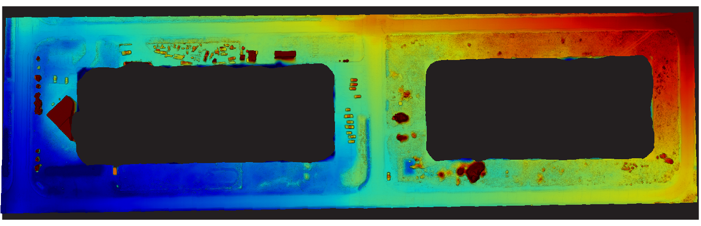
Analyze Every Detail with Drone Elevation Mapping
This elevation map, captured with advanced drone technology, highlights variations in terrain with precise color-coded data. From construction planning to land surveying, this tool helps you visualize elevation changes and make informed decisions for your projects.
See the Full Picture with Orthomosaic Imaging from Drone Photographs
This orthomosaic map, created with advanced drone imaging technology, provides a seamless and detailed top-down view of your property. By stitching together multiple high-resolution images, it offers a comprehensive perspective that is both accurate and easy to analyze. Ideal for large acreage, construction sites, or agricultural fields, this tool allows you to assess property layout, identify key features, and make informed decisions with confidence.

High Definition
Premiere Drone Video Project Examples
Our HD aerial videos highlight a variety of projects, from expansive construction sites to vibrant retail areas and large operational facilities. These videos offer a unique perspective ideal for marketing, documentation, and sharing milestones with clients and stakeholders. Explore how our aerial footage brings projects to life.
Applications
- Construction Site Monitoring
- Commercial Real Estate
- Luxury Homes
- Time Lapse
- Sporting Events
- Festivals


Aerial Imagery
High Resolution Drone Photography Project Examples
Our drone photography showcases a range projects, offering unique perspectives and detailed visuals. From documenting construction progress to presenting commercial properties or capturing the energy of special events, these images reflect the quality we bring to every project.


